Google Earth Engine(GEE)——基于Landsat的1985-2020年美国西部地区土地分类数据集
数据介绍:
美国西部的牧场生态系统对气候变化、火灾和其他人为干扰有动态反应。牧场状况、监测、评估和预测(RCMAP)产品旨在通过使用1985-2020年的Landsat图像量化美国西部牧场组成部分的覆盖百分比、相关误差和趋势来捕捉这种反应。
RCMAP使用1985-2020年的Landsat图像,量化了美国西部牧场各组成部分的覆盖率(根据Rigge等人,2020)。RCMAP时间序列由八个部分组成:一年生草本植物、裸地、草本植物、垃圾、非沙棘灌木、多年生草本植物、沙棘和灌木,以及每个部分的时间趋势。四个主要组成部分(裸地、灌木、垃圾和草木)在与树冠覆盖率相加时,旨在使每个像素的总和达到100%。次要成分一年生草本植物和多年生草本植物是主要成分草本植物的子集,而非沙棘灌木和沙棘是灌木的子集。次要成分的覆盖率不能大于其各自的主要成分。由于缺乏高质量的图像,有一年,即2012年,被排除在时间序列之外。
MRLC开发了一种自动方法来识别Landsat档案中每一年和2016年左右的基础地图之间的光谱条件变化。回归树模型是根据时间序列中每年的未变化部分进行训练的。后处理模型纠正了烧毁后的轨迹,并消除了预测中的噪音和不符合逻辑的变化。目前这一代的RCMAP已经得到改进,有了更多的训练数据、区域尺度的Landsat合成物和更强大的变化检测。MRLC用线性模型和结构变化方法评估了每个组成部分的时间模式,结构变化方法使用8年的时间移动窗口确定时间序列中的断点。线性方法和结构变化方法在变化的总体模式上基本一致,但后者更经常发现断点,大多数像素至少有一个断点。数据提供了关于断裂发生的时空信息,但更关键的是,将这些变化事件归于特定的成分。关于牧场状况的空间、时间和主题(即多成分)的详细具体信息,有助于理解地方、区域和大陆层面的主要变化模式。
Dataset Availability
1985-01-01T00:00:00Z - 2020-12-31T00:00:00
Dataset Provider
United States Geological Survey and Bureau of Land Management
Earth Engine Snippet
ee.ImageCollection("USGS/NLCD_RELEASES/2019_REL/RCMAP/V4/COVER")
波段:
Resolution
30 meters
Bands Table
| Name | Description | Min | Max | Units |
|---|---|---|---|---|
| rangeland_annual_herbaceous | Percent of the pixel covered by annual herbaceous vegetation. | 0 | 100 | % |
| rangeland_bare_ground | Percent of the pixel covered by bare ground. | 0 | 100 | % |
| rangeland_non_sagebrush_shrub | Percent of the pixel covered by non-sagebrush shrubs. | 0 | 100 | % |
| rangeland_herbaceous | Percent of the pixel covered by herbaceous vegetation. | 0 | 100 | % |
| rangeland_litter | Percent of the pixel covered by litter. | 0 | 100 | % |
| rangeland_sagebrush | Percent of the pixel covered by sagebrush (*Artemisia* spp). | 0 | 100 | % |
| rangeland_shrub | Percent of the pixel covered by shrub. | 0 | 100 | % |
| rangeland_perennial_herbaceous | Percent of the pixel covered by perennial herbaceous vegetation. | 0 | 100 | % |
文献引用:
-
Rigge, M.B., Bunde, B., Shi, H., Postma, K., 2021, Rangeland Condition Monitoring Assessment and Projection (RCMAP) Fractional Component Time-Series Across the Western U.S. 1985-2020 (ver. 2.0, October 2021): U.S. Geological Survey data release. doi:10.5066/P95IQ4BT
代码:
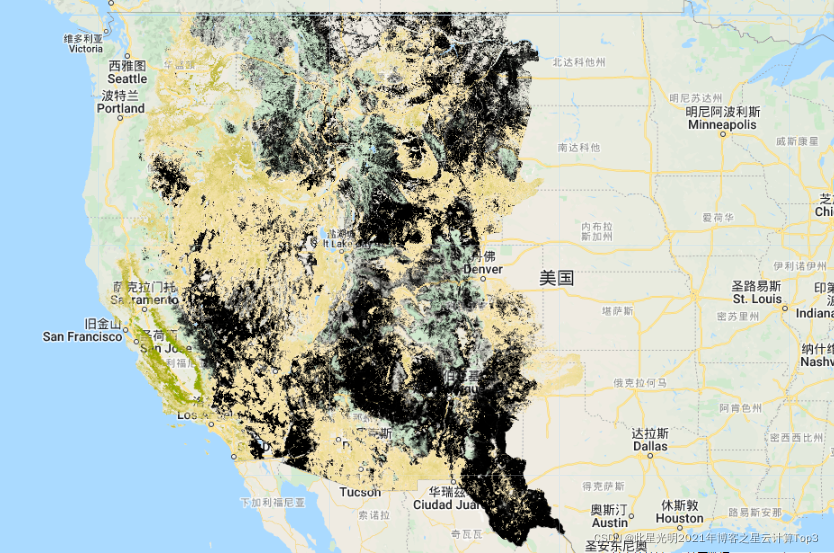
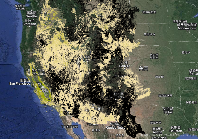
// 加载 NLCD RCMAP 数据集var dataset = ee.ImageCollection('USGS/NLCD_RELEASES/2019_REL/RCMAP/V4/COVER');//时间筛选,并选出第一景影像var nlcd2016 = dataset.filter(ee.Filter.eq('system:index', '2016')).first();//打印16年影像的第一景结果print('Bands:', nlcd2016.bandNames());// 一年生草本植物覆盖的像素的百分比。var landcover = nlcd2016.select('rangeland_annual_herbaceous');var vis = { 'palette': [ "000000", "f9e8b7", "f7e3ac", "f0dfa3", "eedf9c", "eada91", "e8d687", "e0d281", "ddd077", "d6cc6d", "d3c667", "d0c55e", "cfc555", "c6bd4f", "c4ba46", "bdb83a", "bbb534", "b7b02c", "b0ad1f", "adac17", "aaaa0a", "a3a700", "9fa700", "9aa700", "92a700", "8fa700", "87a700", "85a700", "82aa00", "7aaa00", "77aa00", "70aa00", "6caa00", "67aa00", "5fa700", "57a700", "52a700", "4fa700", "4aa700", "42a700", "3ca700", "37a700", "37a300", "36a000", "369f00", "349d00", "339900", "339900", "2f9200", "2d9100", "2d8f00", "2c8a00", "2c8800", "2c8500", "2c8400", "2b8200", "297d00", "297a00", "297900", "277700", "247400", "247000", "29700f", "2c6d1c", "2d6d24", "336d2d", "366c39", "376c44", "396a4a", "396a55", "3a6a5f", "3a696a", "396774", "3a6782", "39668a", "376292", "34629f", "2f62ac", "2c5fb7", "245ec4", "1e5ed0", "115cdd", "005ae0", "0057dd", "0152d6", "0151d0", "014fcc", "014ac4", "0147bd", "0144b8", "0142b0", "0141ac", "013da7", "013aa0", "01399d", "013693", "013491", "012f8a", "012d85", "012c82", "01297a", ]};// 加载在地图上,也就是植被覆盖的百分比%Map.setCenter(-114, 38, 6);Map.addLayer(landcover, vis, 'Rangeland Annual Herbaceous %');局部放大后的展示:
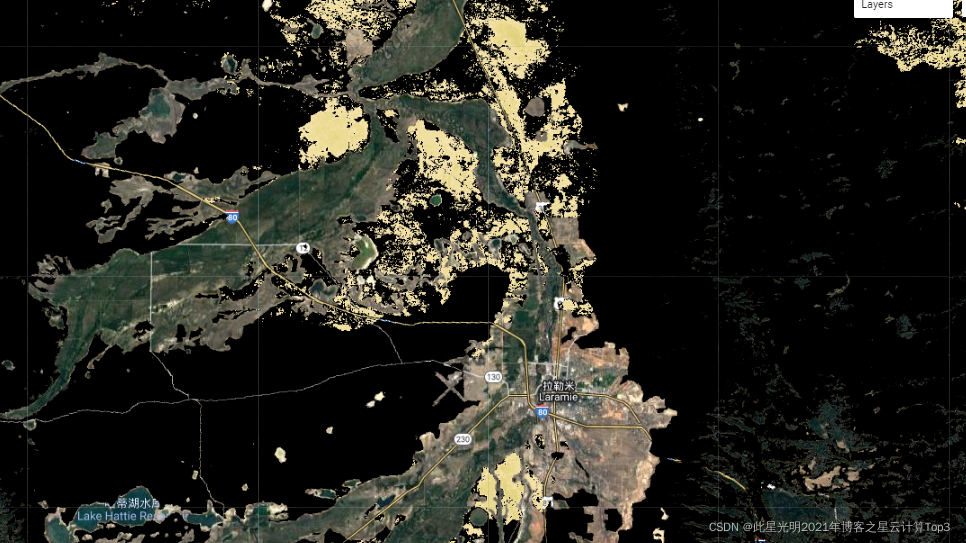
结果: